In 2009,
in response to a challenge from NOAA to assess the utility of using AUVs, I chaired the development and
delivery of a workshop called “AUVs in the Bay”. We gathered 4 AUVs to the Chesapeake Bay Foundation’s
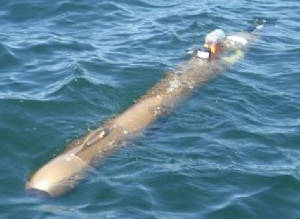
facility in Annapolis. The AUVs were assigned an area off of the beach to map. Rutgers, University of Delaware, YSI (Ocean
Mapper), and the Naval Academy launched their AUVs, collected side scan data and some water quality data. The day following
deployment the data was presented to the group of AUV users, data and resource managers, and a group of high school teachers
and their students. Larry Mayer delivered the program keynote talk barefoot. Teledyne RDI kicked in $2,000 to support the
inclusion of teachers and their students in the workshop.
In
2010. The steering committee decided that we had proven the utility of AUV use in shallow water and now
we wanted to show how they could be used in an observation system. With support from the Integrated Ocean Observing System
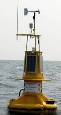
Program NOAA’s Chesapeake Bay office a small observation system utilizing a newly deployed Chesapeake Bay, John Smith
Water Trail Buoy, a couple of buoyed water column profilers, a slew of AUVs, a NASA deployed kite, and an automated surface
vessel was activated. This workshop was name Bay and Estuarine Sensor Technology (BEST) Workshop. The dynamic data collected
y the AUVs was compared to the time stamped information collected by the static buoyed systems. All in all, it was demonstrated
that the combined technologies would define observation systems in the future. Unfortunately, the sensors deployed on the
AUVs did not necessarily record the most accurate information. AUV sensors got glommed with jellyfish, and a set of the same
sensors deployed on the same AUV collected significantly different water quality data. Teledyne RDI sponsored donate $2,000
for the educational component of this workshop which was hosted at NOAA’s Cooperative Oxford Laboratory
in Oxford, MD.