Dr. Levin has 40 years of global experience deploying technology
to evaluate benthic habitats. He has hands-on experience with a multitude of seafloor mapping systems, including DGPS,
multi-beam, side scan sonar, sub bottom profilers, ADCPs, ROVs, AUVs and magnetometers. Project experience spans
oil seep detection off of Cartagena, SA; Lease Block Hazard Surveys; pipeline and fiber optic cable route selections in the
Gulf of Mexico, the Aleutian Islands and the Med; shipwreck imaging in Thunder Bay; and searching for
evidence of Noah’s deluge in the Black Sea. He’s participated in NASA’s airborne LIDAR Ice Mapping missions
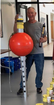
in Iceland and Greenland. He is responsible for developing low cost buoy systems (Basic Observation Buoys) to
increase the resolution of data to monitor water quality in all aquatic/marine systems.
Since 1980, He’s held private sector,
academic, and federal government positions focused primarily on the marine technology industry. His career has melded science
and outreach education programs where he’s created the One-Watershed Catalog of STEM education programs
for systemic outreach for K-12 programs in Maryland, including NOAA adopted underwater robotics kits and buoy building. His
responsibilities have included program, project, and grant management; business development; program design; proposal
writing and review; technical coordination; planning, execution, and oversight of field operations; education curriculum/lesson
plan development; data analysis; formal and informal presentations and report writing. From 2011 to January of 2023 was been
with Washington College where he founded the Watershed Innovation Laboratory. Now he's a Research Associate
with the University of Delaware, mapping oyster beds in Maryland, building Basic Observation Buoys, and continuing to work
with various partners and not doing a good job "slowing
down"....